| dc.contributor.author | Foye, Kylie | |
| dc.date.accessioned | 2020-10-29T20:34:35Z | |
| dc.date.available | 2020-10-29T20:34:35Z | |
| dc.date.issued | 2019-06-17 | |
| dc.identifier.uri | https://hdl.handle.net/1721.1/128256 | |
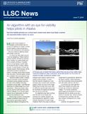
| dc.description.abstract | In remote areas of Alaska, pilots check current or forecasted weather conditions before they fly, but a lack of automated weather observation stations throughout the Alaskan bush makes it hard to know exactly what to expect. To help, the FAA recently installed 221 web cameras near runways and mountain passes. Pilots can look at the image feeds online to plan their route. Still, it’s difficult to go through what could be hundreds of images and estimate just how far one can see. Laboratory staff have been working with the FAA to turn these web cameras into visibility sensors and have developed an algorithm, called Visibility Estimation through Image Analytics (VEIA), that uses a camera’s image feed to automatically determine the area’s visibility. These estimates can then be shared among forecasters and with pilots online in real time. | en_US |
| dc.language.iso | en_US | en_US |
| dc.publisher | MIT Lincoln Laboratory | en_US |
| dc.relation.ispartofseries | MIT Lincoln Laboratory News; | |
| dc.rights | Attribution-NoDerivs 3.0 United States | * |
| dc.rights.uri | http://creativecommons.org/licenses/by-nd/3.0/us/ | * |
| dc.subject | Lincoln Laboratory | en_US |
| dc.subject | Supercomputing | en_US |
| dc.subject | LLSC | en_US |
| dc.title | An algorithm with an eye for visibility helps pilots in Alaska | en_US |
| dc.type | Article | en_US |