Mapping the topography of Mercury with MESSENGER laser altimetry
Download004489_10.pdf (1.356Mb)
PUBLISHER_POLICY
Publisher Policy
Article is made available in accordance with the publisher's policy and may be subject to US copyright law. Please refer to the publisher's site for terms of use.
Terms of use
Metadata
Show full item recordAbstract
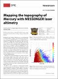
The Mercury Laser Altimeter (MLA) is one of seven instruments on NASA’s MErcury Surface, Space ENvironment, GEochemistry, and Ranging (MESSENGER) spacecraft. MESSENGER was launched on 3 August 2004, and entered into orbit about Mercury on 18 March 2011 after a journey through the inner solar system. This involved six planetary flybys, including three of Mercury. MLA is designed to map the topography and land- forms of Mercury’s surface. It also measures the planet’s forced libration (motion about the spin axis), which helps constrain the state of the core. The first science measurements from orbit taken with MLA were made on 29 March 2011 and continue to date. MLA had accumulated about 8.3 million laser ranging measurements to Mercury’s surface, as of 31 July 2012, i.e., over six Mercury years (528 Earth days).
Date issued
2012-10Department
Massachusetts Institute of Technology. Department of Earth, Atmospheric, and Planetary SciencesJournal
SPIE Newsroom
Publisher
SPIE-Intl Soc Optical Eng
Citation
Sun, Xiaoli, John Cavanaugh, Gregory Neumann, David Smith, and Maria Zuber. “Mapping the Topography of Mercury with MESSENGER Laser Altimetry.” SPIE Newsroom (October 26, 2012).
Version: Final published version
ISSN
18182259